A dangerous heat wave is overspreading a large area of the United States, and Michigan is right in the center of this heat dome. This uncomfortably muggy and hot weather is going to continue for the next several days.
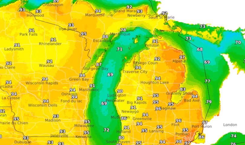
High temperatures today are soaring into the 90s.
Extreme heat is ramping up across both peninsulas. Wednesday and Thursday will likely be the hottest days of the week.
An Extreme Heat Warning is in effect for most of Michigan through Thursday evening as a dangerous combination of high temperatures and humidity creates heat indices reaching 105 to 110 degrees across much of the state.
The hottest conditions are expected Tuesday through Thursday, with high temperatures climbing into the mid to upper 90s and potentially reaching 100 degrees in some locations. Combined with dewpoints in the upper 60s to mid 70s, the heat index will peak in the low 100s on Tuesday and remain at dangerous levels through Thursday.
The National Weather Service has issued Heat Advisories for the Upper Peninsula and Extreme Heat Warnings for Lower Michigan, urging residents to take precautions, stay hydrated, and check on vulnerable populations including the elderly, young children, and outdoor workers.
Little relief is expected overnight, with low temperatures only dropping into the mid 70s and nighttime heat indices remaining near 80 degrees. This lack of cooling presents additional health risks, as bodies will have limited opportunity to recover from daytime heat stress.
Several locations may challenge daily temperature records, particularly on Wednesday and Thursday. Lansing could approach its record highs of 97 degrees on July 1 and 98 degrees on July 2.
The extreme heat is being caused by a strong upper-level ridge centered over Kentucky, with 850-millibar temperatures reaching 22 to 24 degrees Celsius on Tuesday. A strong capping inversion will limit thunderstorm development through Wednesday, though isolated severe storms remain possible Tuesday afternoon and evening across western portions of the state, with damaging winds up to 80 mph being the primary threat.
Dense fog advisories are in effect for portions of Lake Superior through Tuesday morning.
Looking ahead to Friday and the Independence Day weekend, temperatures should moderate slightly as the ridge begins to flatten, though conditions will remain warm and humid with highs in the upper 80s to low 90s. Chances for showers and thunderstorms will increase late Thursday into the weekend as multiple weather disturbances move through the region. The active weather pattern is expected to continue into next week, with daily chances for thunderstorms, some of which could be strong to severe.
Lakeside communities, particularly along Lake Michigan north of Holland, will experience somewhat cooler temperatures due to onshore winds, though heat indices will still reach uncomfortable levels. An Air Quality Alert has also been issued for parts of southern Lower Michigan from midnight Monday through midnight Tuesday due to elevated ozone levels associated with the heat.