By: Dan Blair, CLMCD Watersheds Coordinator
The Munuscong River Watershed consists of all the surface and groundwaters that drain into the Munuscong and Little Munuscong Rivers. The watershed as a whole covers 149,101 acres, an area equivalent to almost 233 square miles. The watershed is broken down into two sub-basins, the Little Munuscong River sub-basin to the north and the Munuscong River sub-basin to the south. This is then further broken down into nine subwatersheds. These include the Headwaters Munuscong River, Upper Munuscong River, Taylor Creek, Middle Munuscong River, Hannah Creek, East Branch Munuscong River, Lower Munuscong River, Headwaters
Little Munuscong River, and Little Munuscong River.
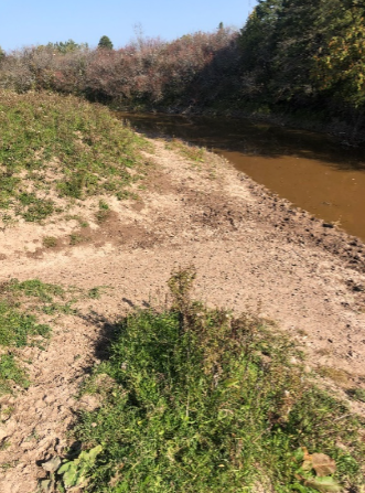
River accelerates streambank erosion
Like much of the Great Lakes area, the Munuscong River Watershed was highly influenced by glacial activity. Glaciers dug into the Earth and carved out the Great Lakes Basin thousands of years ago. As the climates warmed, these ice sheets melted and filled in these carved out areas. The Munuscong River Watershed was once the lake bottom for the glacial lakes Algonquin and Nipissing. This area dried up some 10,000 years ago, but the effects are still felt. Much of the area is covered with thick, impermeable clay. This clay presents obstacles for agricultural and urban development.
Land use and land cover has been changed drastically since settlement of the area. Prior to settlement, the watershed was approximately 59% wetland and 41% upland forest. Today, the watershed is 40% wetland, 23% upland forest, 28% agriculture, 3% urban, and 6% open field. This change has been largely due to agricultural and urban development.
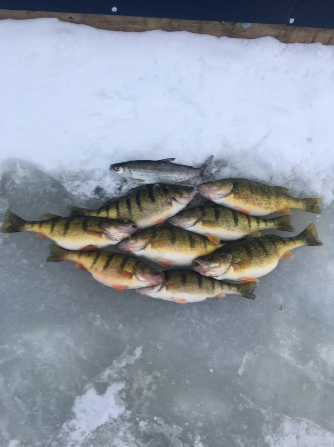
into the St. Marys River system which
supports a dynamic fishery
What effects has this change in landscape and increase in development had on the watershed? A decrease in wetlands and upland forests has caused loss of habitat to several species in the area. Agricultural practices near waterways continue to increase nutrient levels within the watershed, particularly nitrogen and phosphorus. Streambanks are eroding at a higher rate due to livestock access. Urban development has shifted stormwater runoff dynamics. When an area becomes paved, water cannot drain into the ground. Instead, the water will flow along any slope and deposit into concentrated areas. This runoff in urban areas is high in pollutants as it picks up gas, oil, road salt, and any other pollutants that may be present. Another concern in these developed areas is septic waste from households. Many septic systems in the watershed area are either outdated or not functioning correctly for the soils that are present. This means wastewater from households and businesses are potentially being deposited right into our waters.
What does all of this mean for the future of the Munuscong River watershed? Waters that many generations have relied on are being changed due to our practices. Much of the Eastern Upper Peninsula’s economy is reliant on our natural resources. The Munuscong River Watershed feeds into the St. Marys River System which supports a prestigious walleye, salmon, and perch fishery, along with an area high on recreational activities. Alongside these natural resources is a community that is rooted deep in agriculture and small business practices. Several organizations are working on preserving our natural resources. The Chippewa Luce Mackinac Conservation District is working hard with the community to raise awareness of our natural resources. The CLMCD is also working directly with landowners within the watershed to implement new practices that will preserve our most important resource – water. We, as a community, must work together to ensure the quality of our natural resources are maintained as we move toward the future.

- UPDATED: State Police Seek Help in Locating Missing Juvenile - July 25, 2026
- Michigan Prisoner Charged with Brutal Slaying of His Own Cellmate - July 25, 2026
- MSP Warns of Scam Calls Targeting Michigan Residents - July 24, 2026